Project 1:Atlantic & Burlington County Sites
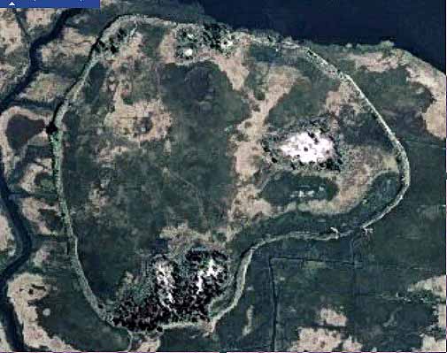
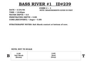
239 - Bass River #1
Five of the seven sites along the Bass River plus the two Collins Cove sites appear to be associated with roadbed construction for the Garden State Parkway back in the 1950’s because the highway rests on a bed of fill over 2 miles in length leading to the fixed bridge crossing the Mullica River. Bass River #1 is a confined disposal site that has lain abandoned since the 1950’s. There is a low berm surrounding the site, but time has created at least 5 breaches through the berm that allow tidal flow into and out of the feature. This site is positioned near the Garden State Parkway where it crosses the Mullica River basin. Three distinct deposits of coarse sandy gravel cover about a quarter of the interior area with the remainder as normal salt marsh growth. Just north of the site is a “lagoon” that covers twice the area of this CDF and was discovered to be between 35 and 30 feet deep throughout with near-vertical walls to the marsh surface. It is presumed that dredging dug a deep basin in the marshes to recover the coarse valley-fill deposits that make up the Mullica floodplain prior to being flooded by sea level rise. This and Bass River #5 appear to have been used to sort out fine material from the desired coarse sand and gravel used to build the highway. |
|
|
|
|
|
|
|