Project 2:
Overview
In order
to implement a sustainable regional approach to dredged material management,
a comprehensive understanding of the nature of sediment that is in the
system is necessary. Program 2 is aimed at determining the bay floor
sediment characteristics and gain information on sediment distribution
dynamics in thorofares and channels in New Jersey's back-bays. This portion
of the project was designed to measure the physical sedimentary parameters
of grainsize and distribution, to define the variables and provide them in a
concise standardized database.
The projects specific goals were to:
-
Provide information to assist in prioritizing relative importance of
individual disposal sites as part of the process of achieving the goal
of maintaining navigability along New Jersey's waterways,
-
Define the character of in-situ bay-floor sediments, and
-
Determine sediment transport dynamics in and around the NJIWW, state
channels and rivers.
Sediment
Collection
Identifying and mapping the distribution of
sediments is important to developing a regional framework for dredged
material management. Knowing what comprises the bay-floor helps reduce the
need to “reinvent the wheel” each time a dredge project occurs.
Bayfloor sediment samples were collected throughout Atlantic County to map
and characterize (i.e. percent sand vs. percent silt/clay) the sediment and
show movement/distribution of sediment in the coastal waterways. Sediment
sample locations were randomly generated using ArcView GIS software.
Engineering judgment was used to determine sufficient point coverage/ sample
location density to assure that major thorofares and waterways were covered
by the sampling plan. Samples collected were later analyzed for
stratigraphic trends/changes, sand/silt ratio, and mean grain size.
Sediment Distribution
Distribution mapping of in-situ bay-floor
resources is a valuable tool for observing and predicting sediment transport
rates in much of New Jerseys backbays and waterways and identifying areas as
depositional “hotspots” or priority areas for future dredging. Physical
characterization of sediments (i.e. grain size) is a useful for providing
location and quantity of sediment types that could potentially be utilized
in a variety of projects that might incorporate dredge material in the
project development and execution. The material found in these channels is
what comprises New Jersey’s various coastal habitats. Therefore, the
possibility exists for utilizing this material in wetland, coastal marsh or
beach-front restoration. Bottom substrate is a key factor in defining
sub-aqueous habitats, so this information will also benefit fishery, shell
fishery, and other environmental assessments of New Jersey’s inland waters.
Sediment distribution maps were created in ArcView GIS using data collected
during the bayfloor sediment sampling phase of the project. The resulting
maps have information showing the distribution of sediment types (sand vs.
silt/clay) throughout Atlantic County.
Shoaling Analysis
Modeling sediment transport and potential shoaling
hotspots was done using remote sensing techniques incorporating elevation
and imagery data in a GIS environment. Using this technique, in conjunction
with ground truthing/field observations during bayfloor sediment sampling
efforts, it was possible to identify areas where shoaling is occurring or
likely to occur. This information, combined with data from the bayfloor
sediment sample collection is integral in determining priority areas of New
Jersey’s back bays that are in need of, or are soon to be in need of
dredging, as well as a reasonable determination of the material to be
dredged.
|
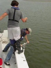
Bayfloor sediment sample collection using a piston core over the side of a
Stockton vessel.
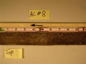
Photograph displaying typical stratigraphy of a bayfloor sediment sample
collected in Atlantic County.
|

