Project 1:Ocean A total of 103 sites were
identified for Massive development roared onto
the scene with the prosperity that followed WW II and the construction of the
Garden State Parkway in the early 1950’s.
This combination of easy access to Ocean County by car and people with
money to spend brought out wholesale construction of second home projects at
every landing that had the remotest access to the waters of Barnegat
Bay. The marshland was cheep and the
dredge/dragline was very cost effective in creating
both the boat slip lagoons and using the material dredged from the lagoons to
create the building lots. King of this
process was the Beach Haven West development that covers 1,500 acres adjacent
to the Route 72 access to Long Beach Island.
This process continued, unchecked by any agency at the State or
Federal level until 1970 when New Jersey passed its Wetlands Law that
required a permit prior to dredging or filling tidal wetlands. This brought a 2,500 acre per year loss
rate in tidal wetlands down to less than 2 acres presently. The results of the 20-year land rush to
develop the bay shore of Ocean County is a legacy of hundreds of sites both
large and small, where dredge material was deposited without oversight
located along the former water course of all but the most insignificant of
the fresh water streams leading into the bay. These sites consist of mounds of
material near the marsh developments, plus unconfined areas of sand and silt
spread along the original water course as efforts were expended in deepening
and widening the stream channel to get larger and larger boats into the
private lagoons being dug. Another
common sight is the existence of areas of salt marsh with a berm surrounding
a pattern of geometrical “ditches” that are almost always adjacent to an
existing development on the former marsh at one of these bayside
communities. These sites are clearly
related to the advent of the 1970 law that required State permits to continue
this work that were never forthcoming.
Today, 40 years later, these sites are slowly reverting to natural
marshes because storm tides acted to breach the berm and re-open tidal flow
into the site. A similar process occurred on the
barrier shoreline side of Barnegat Bay as development spread across the
entire width of the beach including any marsh attached to the island or
northern spit. Here dredging continued
into the last quarter of the 20th Century as the demand for deeper
boat slips and access channels to Barnegat Bay continued. One 13-mile section of shoreline remains in
its natural condition due to the chance that one owner of a large oceanfront
tract would elect to sell the entirety of the southern piece of Northern
Ocean County to the State to become Island Beach State Park. Today the public has access down a
mid-island highway to a pair of bathing beach day-use developments, but must
either walk or take one of several 4-wd sand roads to the beach for
fishing. Access has been provided to
the bay shoreline for the use of kayaks or canoes to experience the Barnegat
Bay known to those who discovered its beauty in the early 19th
Century. In fact, novel legislation
was passed banning motor powered personal watercraft from the bay waters
proximal to the State park marshes and tidal channels along the western park
boundary (The Sedge Island Marine Conservation Zone). This prologue sets the stage for the definition of over 100 sites that were identified and catalogued for this report. More small legacy sites exist, but were either too small to have any significance or were too difficult to gain access to in spite of the mission to cover everything. The work was divided into covering the priority sites with GPS, auger and piston cores as done for similar sites in Atlantic and Cape May Counties, but a conscious effort was made to visit as many legacy sites as time would permit to assess their potential future use to contain dredge material without surveying or sampling those deemed to be too small or located in an area known to be too environmentally sensitive to warrant long battles over necessary permits to convert these sites into true CDF locations. All the abandoned salt marsh development impoundments discovered were not explored in the field since no dredge material other than that derived from the partial digging of the boat slip lagoons was ever pumped into these sites. Groups of small legacy sites parallel to the channel of one of the freshwater streams used for bayshore development were combined in the assessment with just one of each group of sites visited for sediment sampling. Determining ownership proved to be more difficult than either in Atlantic or Cape May County because of the higher percentage of private property ownership and the existence of multiple owners at some of the legacy sites along the freshwater streams crossing the marshes bordering upland Ocean County. The
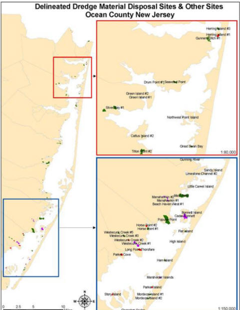
Site Map below
shows the locations of CDFs, CDSs,
and UDSs identified for
Follow this hyperlink to view the Ocean County version in Google Earth: Ocean County Dredged Material Sites Follow this hyperlink to view the full state version in Google Earth: NJ Dredged Material Sites (To view these files, you will need to have Google Earth installed on your computer.)
**The sites highlighted in red are the chosen priority sites which have attributes that favor the possibility of reuse** The following CDF
CDS
UDS or UI: The following sites were delineated as Legacy sites with low potential for reuse. Ownership information is provided in the Database appendix.
|
|
|
|
|
|
|
|